Информационная система
История геологии и горного дела
персоналия
| организация: | Somersetshire Coal Canal Company |
| Связанные документы: | [ Просмотреть ] |
| Связанные фотографии: | [ Просмотреть ] |
| ФИО / Surname, 1st name, 2nd name (in Russian): | Смит, Уильям |
| Имя (русский язык) / 1st name (in Russian): | Уильям |
| Отчество (русский язык) / 2nd name (in Russian): | |
| Фамилия (русский язык) / Surname (in Russian): | Смит |
| Имя (английский язык) / 1st name: | William |
| Фамилия (английский язык) / Surname: | Smith, |
| Век / Century: | XVIII-XIX |
| Дата рождения / Date of birthday: | 1769, 23 марта |
| Место рождения / Place of birthday: | Чёрчилл, Оксфордшир, Англия, Великобритания |
| Дата смерти / Date of death: | 1839, 28 августа |
| Место смерти / Place of death: | Нортгемптон, Англия, Великобритания |
| Ученое звание / Scientific degree: | |
| Область научных исследований / Fields of interest: | Геология / Общие вопросы |
| География исследований / Regions of explorations: | |
| Членство в обществах / Scientific institutions membership: | |
| Биография / Biography: | |
| Библиография / Bibliography: | Основные научные труды У. Смита Smith W. Plan of proposed Somersetshire Coal Canal. London: J. Carry, 1794. 1 p. Smith W. Plan of proposed deviation of Somersetshire Coal Canal. London: J. Carry, 1794. 1 p. Smith W. A map of five miles round the City of Bath. Scale: 1,5 inch to a mile. Bath: A. Taylor & W. Meyler, 1799. 1 p. Smith W. Aсcurate delineation and descriptions of the natural order of the various strata that are found in different parts of England and Wales, with practical observation thereon: Prospectus of work. London: B. M’Millan, 1801. 4 p. Smith W. Mode of improving Boggy Land and account of the nine acres of Water-Meadow on Prisley farm near Fletwick, Westoning and Tingrith in Bedfordshire: Plan of a Water Meadow made out of a Bog on Prisley farm // Trans. Soc. Arts. 1805. N 23. P. 148-172. Smith W. Plan of a Water-Meadow of nine acres made out of a bog at Prisley farm belonging to His Grace the Duke of Bedford // Communications to the Board of Agriculture. 1805. N 4. P. 341: pl. Smith W. Observation on the utility, form and management of Water-Meadow, and the draining and irrigating of peat bogs, with an account of Prisley Bog, and other extraordinary improvements, conducted for His Grace the Duke of Bedford, Thomas William Coke, Esq. M.P. and others. London: R.M. Bacon, 1806. 121 p. Smith W. Strata of England and Wales: [Letter to the editor of Agricultural Magazine, 5 Jul. 1806] // Agric. Mag. 1806. Ser. 2. N 1. P. 21-22. Smith W. The improvement of boggy land by irrigation, as carried into effect // J. Natural Philosophy. 1806. Vol. 15. P. 302-312. URL Smith W. Description of Norfolk, its soil and substrata. Norwich: [s.n.], 1807. [8], 56 p. Smith W. Bath-Easton Coal company: [Report. Bath. 7 March, 1808]. Bath: T.M. Cruttwell, 1808. 2 p. Smith W., Martin E. Bristol and Taunton Canal: Reports of Mr. William Smith and Mr. Martin, on the state of the collieries at and near Nailsea. Bristol: [s.n.], 1811. 8 p. URL Smith W. [The Board of Agriculture sanction Map of the strata]. London, 1814. 1 p. Smith W. A delineation of the strata of England and Wales, with parts of Scotland; exhibiting the collieries and mines, the marshes and fen lands originally overflowed by the sea, and the varieties of soil according to the variations in the substrata, illustrated by the most descriptive names by William Smith. Scale: 1 inch to 5 miles: [1 Aug. 1815]. London: J. Cary, 1815. 16 p.; 2nd ed. 1820. 16 p.; 3rd ed. 1824. 16 p.; 4th ed. 1827. 16 p. Smith W. A memoir to the map and delineation of the strata of England and Wales with part of Scotland by William Smith, engineer and mineral surveyor: [1 Aug. 1815]. London: J. Cary, 1815. XI, 51 p.; Idem [Limited facsimile edition. 1 Aug. 2015]. Leeds: Hollingworth & Moss Ltd., 2015. VI, 26, IX, 51 p. Smith W. [Submission of Mineralogical map for an award to the Society for Encouragement of Arts, Manufactures and Commerce: 8 Feb. 1815] // Trans. Soc. Arts. 1815. N 33. P. 51-60. Smith W. Strata identified by organized fossils, containing prints on colored paper of the most characteristic specimens in each stratum: [1 June 1816]. London: W. Arding [Sherwood, Neely, and Jones, and Longman, Hurst, Rees, Orme, and Brown]. 1816. 24 p. URL Smith W. Geological table of British organized fossils, which identify the course and continuity of the strata in their order of superposition; as originally discovered by W. Smith, civil engineer, with reference to his geological map of England and Wales. London: J. Cary, 1817. 1 p. Smith W. Geological section from London to Snowdon, showing the varieties of the strata, and the correct altitudes of the hills. London: J. Cary, 1817. 1 p. Smith W. Section of strata, North Wilts. London: J. Cary, 1817. 1 p. Smith W. Strata south of London dipping northwards. London: J. Cary, 1817. 1 p. Smith W. Stratigraphical system of organized fossils, with reference to the specimens of the original geological collection in the British Museum: explaining their state of preservation and their use in identifying the British strata. London: E. Williams, 1817. xi, 118 p. Smith W. Geology of England: Mr. Wm Smith claims: [Lithograph pamphlet]. London: [s.n.], 1818. 14 p. Smith W. Mr. Smith’s Report on the State of Monmouth: [10 Feb. 1818]. Health: [s.n.], 1818. 14 p. Smith W. Statement of facts: [Letter to the Committee of Management for the Diss Navigation. 4 Apr. 1818] // Benefits of an improvement in the navigation of the river Waveney: [Printed pamphlet]. Norfolk: [s.n.]. P. 4-11. Smith W. Report on the Plan for draining the Low Ground north and south of the river Went, berween the rivers Aire and Dun, in conjunction with the proposed Aire and Dun canal, and Went branch: [12 Sept. 1818]. Pontefract: W. Hunt, 1818. 10 p. Smith W. A new Geological Atlas of England and Wales (Part the first) containing maps of Kent, Sussex, Norfolk, and Wilts; showing the variety of strata, collieries, mines, etc.: 6 pts. London: J. Cary: Pt. 1. Maps of Norfolk, Kent, Wiltshire, and Sussex. 1819. 4 p.; Pt. 2. Gloucestershire, Berkshire, Surrey and Suffolk. 1819. 4 p.; Pt. 3. Oxfordshire, Buckinghamshire, Bedfordshire and Essex. 1820. 4 p.; Pt. 4. p.; Pt. 5. Yorkshire. 1821. 4 p.; Pt. 5. Nottinghamshire, Leicestershire, Huntingdonshire and Rutland. 1821 (1822). 4 p.; Pt. 6. Cumberland, Durham, Northumberland and Westmoreland. 1824. 4 p. Smith W. Geological view and sections: [Surry; Essex and Hertfordshire; Norfolk and Suffolk; Hampshire and Wiltshire to Bath; Dorsetshire and Somersetshire]. London: J. Cary, 1819. Smith W. A new geological map of England and Wales, with the inland navigations; exhibiting the districts of coal and other sites of mineral tonnage. Scale: 1 inch to 15 miles. London: J. Cary, 1820. 1 p. Smith W. [Syllabus of lectures given in Hull]. Hull: Hull Literary and Philosophical Soc., 1824. 4 p. Smith W. Syllabus of lectures on geology. [s.n.], 1824. 3 p. Smith W., Phillips J. Syllabus of lectures on geology in the Town-Hall, Scarbough. Scarbough: J. Cole, 1824. 4 p. Smith W., Phillips J. Syllabus of 9 lectures in geology. Sheffield: Sheffield Literary and Philosophical Soc., 1825. 4 p. Smith W. On retaining water in the rocks for summer use by Mr. William Smith, engineer, M.Y.P.S.: [Read to Yorkshire Phil. Soc. 6 Mar. 1827] // Phil. Mag. 1827. N 1. P. 415. Smith W. Bed of coal at Robin Hood’s Bay // The Whitby Repository. 1830. N 6. P. 370-372. Smith W. A synopsis of geological phenomena. Oxford: S. Collingwood, 1832. 1 p. Smith W. Stratification in Hackness hills. Scale: 1 inch to 6.5 miles. London: W. Day, 1832. 1 p. Smith W. Deductions from established facts in geology relating to the crust of the globe, its former associated beings, concomitant events and superficial Changes. Scarborough: C. Todd, 1835. 1 p. Smith W. Coal finding // Mag. Nat. Hist. 1837. N 1. P. 645-647. Smith W. Practical distinction in minerals // Ibid. P. 386-387. Smith W. On the variations in the quantity of rain which falls in different parts of the Earth // 8th Meeting of the British Association: [Newcastle. 1838]: Trans. 1838. P. 27-28. Barry C., Beche de la H.T., Smith W., Smith C.H. Report of the commissioners appointed to visit the quarries and to enquire into the qualities of the stone to be used in building the New Houses of Parliament: [16 March, 1839] // Parliamentary Papers. 1839. N 30. P. 523-569. Основная литература о У. Смите Белоусов В.В. Смит Уильям // БСЭ. 2-е изд. Т. 39. 1956. С. 410. A monument to William Smith, LL.D. // Geol. Mag. 1892. Vol. 29. N 2. P. 94-96 : fig. Arkel W.J. William Smith and the stratal terms // The Jurassic system in Great Britain. Oxford: Clarendon Press, 1933. P. 2-8. Bassett D.A. William Smith, the father of English geology and of stratigraphy: an anthology // Geology. 1969. Vol. 1. P. 38-51. Bather F.A. Address at Bath on 10th July, 1926 after unveiling a Memorial Tablet to William Smith. Bath: Bath Royal Literary and Scientific Institution, 1926. 12, [2] p. Boud R.C. The early development of British geological maps // Imago Mund. 1975. Vol. 27. P. 73-96. URL Boulger G.S. Dr. William Smith’s geological maps // Geol. Mag. 1877. Vol 4. N 8. P. 378. URL Cox L.R. New light on William Smith and his work // Proc. Yorkshire Geol. Soc. 1942. Vol. 25. P. 1-99. Cox L.R. William Smith and the birth of stratigraphy. London, 1948. 7, [1] p. (International geological congress. 18th session. London. 1848) Cox L.R., Kellaway G.A., Welch F.B.A. “William Smith” excursion: environs of Bath // International geological congress. 18th session: Guide to excursion A. 3. London, 1948. 12 p. Davis A.G. William Smith’s Geological atlas and the later history of the plates // J. Soc. Biblphy Natur. Hist. 1952. N 2. P. 388-395. Davis G.L. The University of Dublin and two pioneers of English geology, William Smith and John Phillips // Hermathena. 1969. N 109. P. 24-36. Donovan D.T. William Smith’s last geological excursion // Geol. Mag. 1969. Vol. 106. N 2. P. 214-215. Douglas J.A., Cox L.R. An early list of strata by William Smith // Geol. Mag. 1949. Vol. 86. N 3. P. 180-188. Edmonds J.M. The geological lecture courses given in Yorkshire by William Smith and John Phillips, 1824-1825 // Proc. Yorkshire Geol. Soc. 1975. Vol. 40. Pt. 3. N 23. P. 373-412. Eyles V.A., Eyles J.M. On the different issues of the first geological map of England and Wales // An. Science. 1938. Vol. 3. P. 190-212. Eyles J.M. The discoverers: William Smith // Science in action. 1969. N 1. P. 638-639. Eyles J.M. William Smith (1769-1839): a bibliography of his published writings, maps and geological sections, printed and lithographed // J. Soc. Biblphy Natur. Hist. 1969. Vol. 5. P. 87-109. Eyles J.M. William Smith (1769-1839): а chronology of significant dates of his life // Proc. Geol. Soc. London. 1969. N 1657. P. 173-176. Eyles J.M. William Smith (1769-1839) und die Suche nach Kohle in Grossbritannien // Geologie. 1971. Jg. 20. H. 6/7. S. 710-714. Eyles J.M. William Smith, Sir Joseph Banks and the French geologists // Arch. Natur. Hist. 1985. Vol. 1. N 1. P. 37-50. Eyles J.M. William Smith: some aspects of his life and work // Toward a history of geology: Interdisciplinary conference on the history of geology: [New Hampshire. Sept. 7-12. 1967]. Cambridge MA; London: M.I.T. Press, 1967. P. 142-158. Eyles J.M. William Smith: the sale of his geological collection to the British Museum // An. Science. 1967. Vol. 23. P. 177-212. Fitton W.H. Notes to the history of English geology: [Review of 6 works by W. Smith] // Edinburgh Rev. 1818. Vol. 29. P. 310-337; Ibid. // Phil. Mag. 1833. Vol. 2. P. 37-49. Fordham H.G. John Cary: engraver, map, chart and print-seller and globe-maker. 1754 to 1835: a bibliography. Cambridge: Univ. Press, 1925. XXXIV, 140 p. Forster A., Reeves H.J. William Smith and the development of engineering geology in England // Quart. J. Engineering Geol., Hydrogeol. 2008. Vol. 41. P. 165-170. Fuller J. The forty-four yard problem: a cross section by John Strachey annotated by William Smith // Arch. Natur. Hist. 1994. Vol. 21. N 2. P. 195-199. Fuller J. The industrial basis of stratigraphy: John Strachey, 1671-1743, and William Smith, 1769-1839 // Bull. AAPG. 1969. Vol. 53. N 11. P. 2256-2273. Greenough G.B. A physical and geological map of England & Wales: on the basis of the original map of Wm Smith 1815 revised and improved: [3rd ed.]. Scale: 1 inch to 6 miles. London: GSL, 1865. 1 p. Hemingway J.E., Owen J.S. William Smith and the Jurassic coals of Yorkshire // Proc. Yorkshire Geol. Soc. 1975. Vol. 40. P. 297-308. Herries Davies G.L. Whatever is under the Earth: the Geological Society of London 1807 to 2007. London: GSL, 2007. XIII, 356. Jameson R. On colouring geognostical maps // Memoirs, of the Wernerian Natural History Society: [Read Apr. 1808]. 1810. N 1. P. 149-161. Judd J. W. William Smith's manuscript maps // Geol. Mag. 1897. Vol. 4. N 10. P. 439-447. Keyes C.R. Centenary commemoration of William Smith // Pan-Am. Geol. 1927. Vol. 47. N 1. P. 1-10: port. Laudan R. William Smith: stratigraphy without palaeontology // Centaurus. 1974. N 20. P. 210-226. Laudan R. From mineralogy to geology: the foundations of a science. 1650-1830. Chicago; London: Univ. Chicago Press, 1987. XII, 278 p. Mitchel W.S. The centenary of Wm. Smith’s birth // Geol. Mag. 1869. Vol. 6. N 62. P. 356-359. Morrell R.W. William “Strata” Smith // The Freethinker. 1969. Vol. 89. N 21. P. 165 Morton J.L. Strata: How William Smith drew the first map of the Earth in 1801 and inspired the science of geology. Stroud: Tempus, 2001. 160 p. North F.J. Deductions from established facts in geology, by William Smith: notes of a recently discovered broadsheet // Geol. Mag. 1927. Vol. 64. P. 532-540. Oldroyd D.R. Maps as pictures or diagrams: the early development of geological maps // Rethinking the fabric of geology. Boulder: GSA, 2013. P. 41-101. (GSA Special Paper; N 502). Oldroyd D.R. The Earth surveyed and geologically mapped: the territorial imperative // Thinking about the Earth: a history of ideas in geology. London: Atholone, 1996. P. 108-130. Owen J.S. William Smith and the Jurassic coals of Yorkshire // Proc. Yorkshire Geol. Soc. 1975. Vol. 40. P. 297-308. Phillips J. Memoirs of William Smith, LL.D., author of the “Map of the strata of England and Wales”, by his nephew and pupil, John Phillips, F.R.S., F.G.S., Professor of geology and mineralogy in the University of Dublin, author of “Illustrations of the geology of Yorkshire”. London: J. Murray, 1844. viii, [2], 150 p. : 8 ad. : 4 pls. : 13 text-figs. URL Pickford R. William Smith, father of English geology, 1769-1839: a brief memoir of his work in the Bath district. Bath: Bath Municipal Libraries, 1969. [9], [3] p. Sarjeant W.A.S. Smith William, (1769-1839) // Geologists and the history of geology: an international bibliography from the origins to 1978. Vol. 3. N.Y.: Arno Press, 1980. P. 2131-2135. Sedgwick A. Announcing the first award of the Wollaston Prize // Proc. Geol. Soc. London. 1831. N 1. P. 270-280; Ibid. // Addresses delivered at the Anniversary meeting of the Geological Society of London on the 18th February, 1831: London: R. Taylor, 1831. P. 1-11. Sharpe T., Torrens H.S. Introduction // A memoir to the map and delineation of the strata of England and Wales with part of Scotland by William Smith, engineer and mineral surveyor. Leeds: Hollingworth & Moss Ltd., 2015 P. 1-26. Sheppard T. William Smith: his maps and memoirs // Proc. Yorkshire Geol. Soc. 1917. Vol. 19. P. 75-253. Torrens H.S. An introduction to the life and times of William Smith (1769-1839) // Memoirs of William Smith, LL.D., author of the “Map of the strata of England and Wales”: by his nephew and pupil, John Phillips, F.R.S., F.G.S. First published in 1844. Bath: Bath Royal Literary and Scientific Institution. 2003. P. XIII-XXXVIII. Torrens H.S. Smith, William (1769-1839) // Oxford Dictionary of National Biography. Oxford: Oxford Univ. Press, 2004. Torrens H.S. The water-related work of William Smith (1769-1839) // 200 years of British hydrogeology. London: Geological Soc., 2004. P. 15-30. (GSL Special Publication: N 225). William Smith Meeting 2015: 200 years of Smith’s Map: [London. 23-24 Apr. 2015]: Abstracts. London: GSL, 2015. 58 p. Winchester S. The map that changed the World: William Smith and the birth of modern geology. N.Y.: Perennial, 2001. 329 p. Woodward H.B. The history of the Geological Society of London. London: GSL, 1907. 334 p. Woodward H.B. William Smith LL.D. “Father of English geology” // Proc. Bath Natur. Hist. Antiq. Fld. Club. 1902. Vol. 10. Pt. 1. P. 1-14. Составитель И.П. Второв |
| Фотогалерея / Photo: | 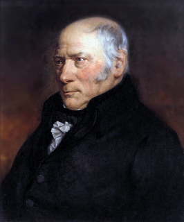 |
| Ссылки / links: | |
| Автор записи: | admin |
| Дата/время последнего изменения: | 2015-11-20 11:47:22 |
Вы не можете изменять эту запись.
Программное обеспечение: Н. Каленов, А. Сенько, М. Якшин.
Автор идеи и редактор содержания – И.Г. Малахова (Группа истории геологии. Геологический институт РАН)